Running House D&D this Wednesday, or so I'm told. ("House D&D" being "Basic D&D with housemates and associates, including girlfriend-types and not specifically aimed at super grognards the way we usually roll around here".) Last time (the first time), we ran one session of the (banned) orange-cover version of B3 Palace of the Silver Princess (weirdness very much in - see
HERE for details (UNLESS YOU'RE PLAYING AND THAT MEANS YOU, YOU SNEAKY ENGLISH K'NIGITS)). They spent most of the session getting there (jumping around city roofs and playing 007 before getting to the green dude with the hook), and then proceeded to make it a hundred feet or so in, blunder into a pit trap, and get their asses more or less handed to them by militaristic kobolds. Barely managing to force a failed morale check, driving the overly-effective dogmen away, the party limped back to the entrance, short a player character.
So now they're in need of warm bodies and an outfitter. (Besides the dead PC from last time, we may have one or two new players.) They're in poor shape for the "wander around until we inevitably run across imprisoned adventurers" thing, so that means travel. I'm loathe to handwave such things - sure, you can say "you get to town X with Y random encounters on the way", but I dig when things evolve a bit more organically. TO THE MAPPING CHAMBER.

I'm basing this on the overland map in (orange-cover) B3, sort-of-mostly shoehorned into the corresponding area from the Mystara map included in the D&D Rules Cyclopedia. Which is not to say I'm giving much if any weight to the Mystara stuff that's gone before - the material from B3 is pretty clearly out of line with what's been published for this area since, and I'm not a huge Mystara scholar anyway - but I figure I have the RC, and the pretty map pages in it, I may as well make use of it for the surrounding areas. Most of what I've done here is actually just North of the extreme Northwest corner of the RC Mystara map - which also means that the Western border of my map is "off the charts", even in the source material. So that's where I can get freaky-crazy - I'm envisioning a vast, weird steppes area populated by barbarians and giant animals (stolen from Judges Guild, natch), with a spice road across it and lots of "on the road" zaniness. With a nice, dangerous reputation to keep folks away from it before I've actually done any of the design work, of course. :D
With that context in mind, I spent some time mapping the locations and routes (roads, paths and rivers) from B3 onto my RC-based hex map. (Using the 5-mile Judges Guild scale for this.) (Yes I know it was supposed to be 15 miles, no I don't care.) Some map distortion crept in getting things to fit where I wanted them, but I managed to more or less preserve the distances between locations, so fuck it. From there, we have a pretty bare map. Time to flesh it out.
Using the "habitation" table from the AD&D DMG (pg. 173), I rolled the "chance of habitation" for every hex in a 15 x 15 hex area. Any weird results (assuming that the main towns were those on the map, and that there weren't a bunch of extra cities, for example) were massaged out (either moved somewhere useful, or ignored). Got a bunch of small thorps & hamlets, a ton of individual settlements / camps, and more than a few ruins. Using the "race of settlement ruler" table from
Kellri's GDD#4, we find that there are a lot of displaced dwarven settlements in the area (presumably refugees from the Palace's fall) (used tons of
Dwarf Fortress names for these, of course), and a couple of powerful retired adventurers living in the valley as well.
And here's where we're at (with water colored in, figuring not much there is gonna change or need erasing at this point):

With the terrain and main settlements arrived at, I have a pretty good basis to fill in the blanks with lots of results from the Judges Guild ruins & relics table, and then it's hexcrawl time. YEEAAAAAAAAHHHHHH
- DYA
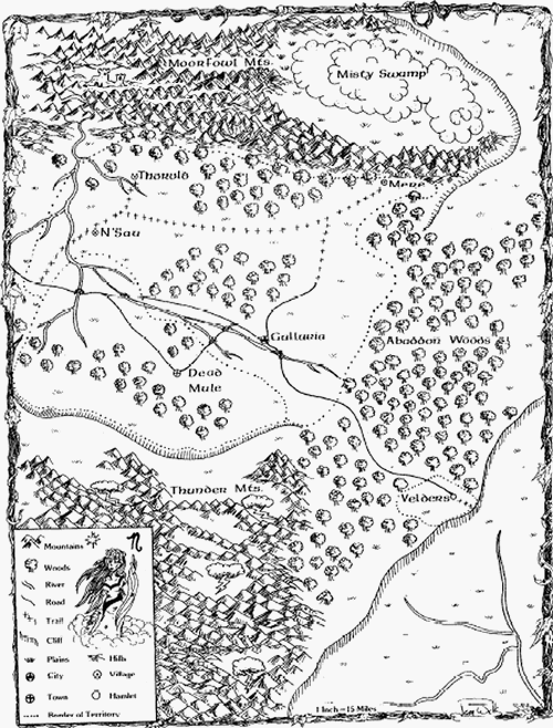
Edit: I figured it'd be illuminating to include the map I based my work off of. So there.


